Image Page on South America
Insert pictures, and at least one panorama image, and a webcam image from two different times.
Outline
- Landscapes
- Iguazu Falls
- Galapagos Islands
- Amazon River
- Perito Moreno Glacier
- Cities
- Cartagena, Colombia
- Santiago, Chile
- Lima, Peru
- Buenos Aires, Argentina
- Landmarks
- Machu Picchu
- Christ the Redeemer
- Easter Island
- Lake Titicaca
- Images of People
- Peru Children
- Amazon Tribe
- Proud Chileans
- The Uru People
- Images from the book
- Carnaval Woman
- Banos Waterfall
1 Landscapes
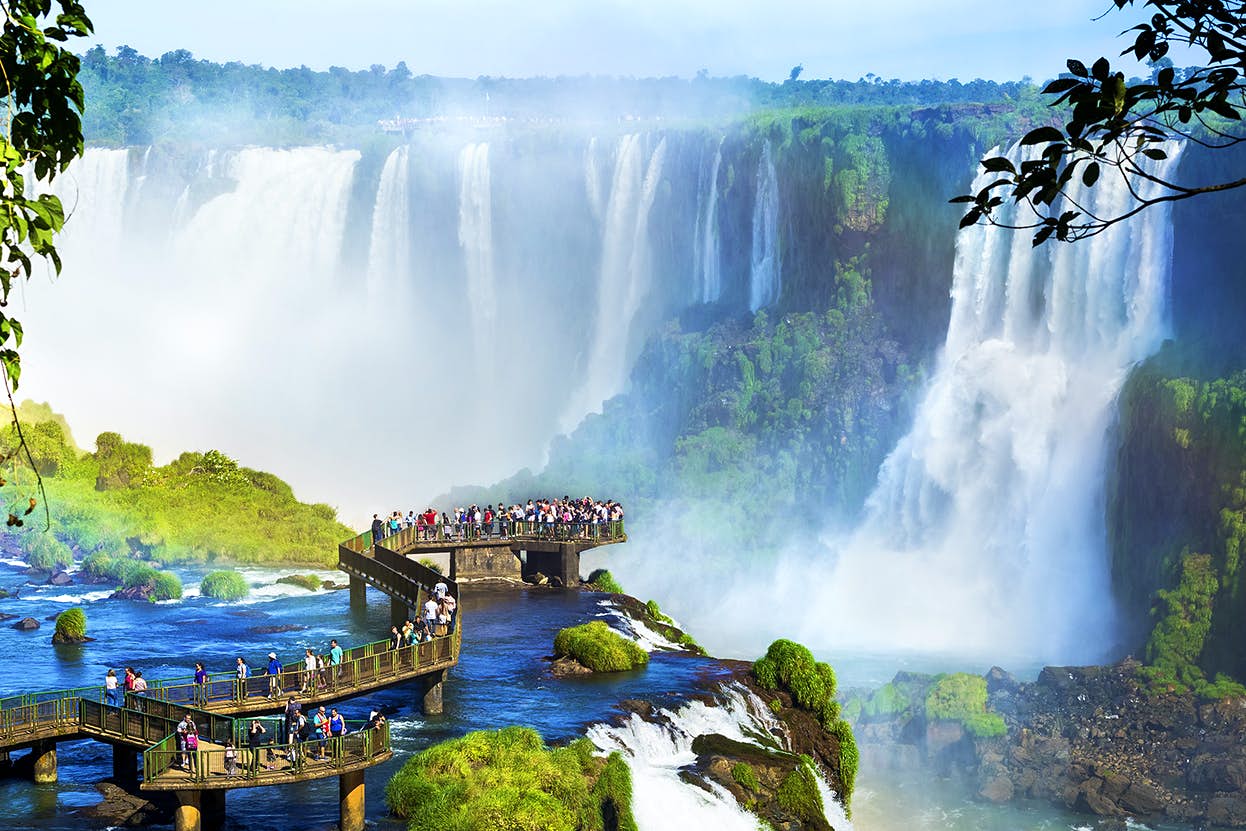
Iguazu Falls, although twice the width of Niagara Falls and almost twice the height is the sixth largest waterfall in the world. These beautiful falls are located on the border of Argentina and Brazil and are made of 275 different, individual falls that bring in over 1.5 million visitors annually. Walkways go throughout the site and even lead to the U-shaped center of the falls called Devil's Throat. The rainforest surrounding the falls and the falls themselves are home to more than 2000 plant species, 400 bird species, countless insects and multiple mammals and reptiles. This photo shows the beauty of Iguazu Falls, taken by rmnunes- Getty Images.
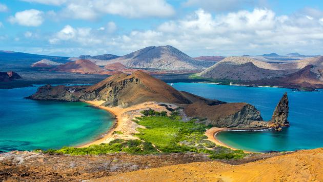
The Galapagos Islands are an island chain formed by volcanoes found about 600 miles off the coast of Ecuador located in the Pacific Ocean. These islands are home to the most diverse plant and animal species that are not found anywhere else in the world. Wildlife inhabits these islands making this a perfect destination for any wildlife enthusiast and photographers. More than 90% of the islands are a national park so they are heavily protected. The Galapagos were made a UNESCO World Heritage site in 1978. This photo shows the beauty of the islands perfectly with the different shades of blue in the surrounding water. Photo by DC Colombia- Getty Images.
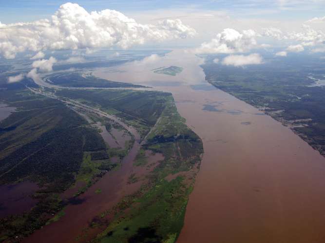
The Amazon River flows more than 4,000 miles through the Amazon rainforest in South America, making it the largest river in the world by discharge volume. It is the second longest river in the world in comparison to the Nile River. Wildlife found within the river is unlike anywhere else in the world, home to 3,000 known species of fish and ocean life and more constantly being discovered. This photo shows the vastness of the Amazon River from above with the murky water that houses all the plant and animal life, surrounded by the Amazon Rainforest. Photo by guentermanaus- Shutterstock.
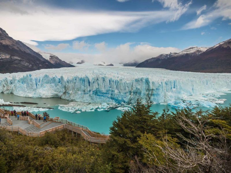
Perito Moreno Glacier surrounded by mountains, lakes and woods is located in Los Glaciares National Park in the southwest Santa Cruz Province of Argentina. It is one of the most popular tourists destinations in the Argentine Patagonia. The glacier is currently 19 miles long and rises about 240 feet above the water, in total it covers about 121 square miles. Unlike other glaciers, Perito Moreno is still growing and continuously has large chunks of ice breaking off into the waters below. You can see the walkway surrounding the glacier in the picture above that takes tourists around to many vantage points, there is also tours that you can take that bring you out on parts of the glacier. Photo by Worldly Adventurer.
2 Cities
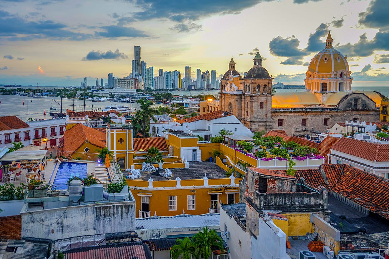
Cartgena, Colombia, it's full name being Cartagena de Indias is a historic destination off the Caribbean coast of Colombia with it's bright buildings and stone walls it is a city like no other. With Colombia's dark past of gangs and drugs it used to be a dangerous place to visit, now tourism has more than tripled in the past 10-15 years making it a popular Caribbean destination. Many of Cartagena's popular attractions are in close proximity to one another making it easy to see many sights within walking distance, the most beautiful buildings in Cartagena happen to be churches usually being the bright yellow color as seen in the photo. Cartagena has a great blend of local street food and upscale restaurants located within the old city walls making it a diverse place to visit. This photo shows a perfect representation of the colorful old town. Photo by Starcevic- Getty Images.
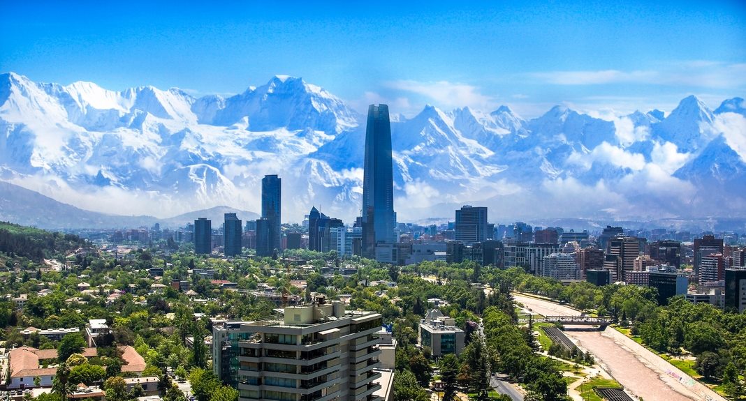
Santiago being the largest city of Chile as well as the capital city is home to 7.04 million people, according to my Lonely Planet South America travel book. The city is filled with Chilean culture and gives off a very lively and versatile vibe. Santiago hosts many festivals and markets throughout the city all throughout the year. Located next to the Andes Mountains, visitors can make a day trip for a hike or admirer the beauty. Santiago is filled with beautiful parks, libraries, museums and Mapocho, the river that runs through Chile's capital city that you can see in the photo above. The photo above shows the impressive mountainous region that is the backdrop of Santiago. Photo by Marianna Ianovska- Shutterstock.
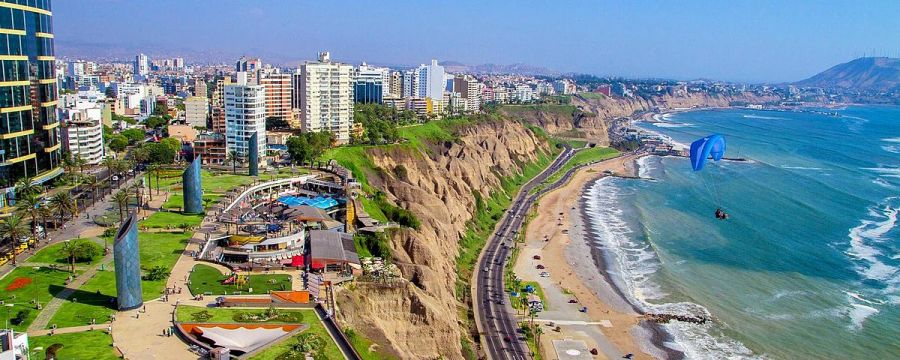
Lima, being the capital city of Peru as well as the largest city in Peru with a population of 9.75 million is the second-driest capital city in the world, after Cairo. Lima is located off the central coast of Peru, overlooking the Pacific Ocean. This city has so much to offer to its natives as well as its visitors, with its colonial-style architecture and history from gaining its independence in 1821, the food, the nightlife, the surfing, there's something for everyone in this Peruvian land. This photo shows the beauty of this coastal city located right off the cliffs next to the blue ocean. Could not find photo source.
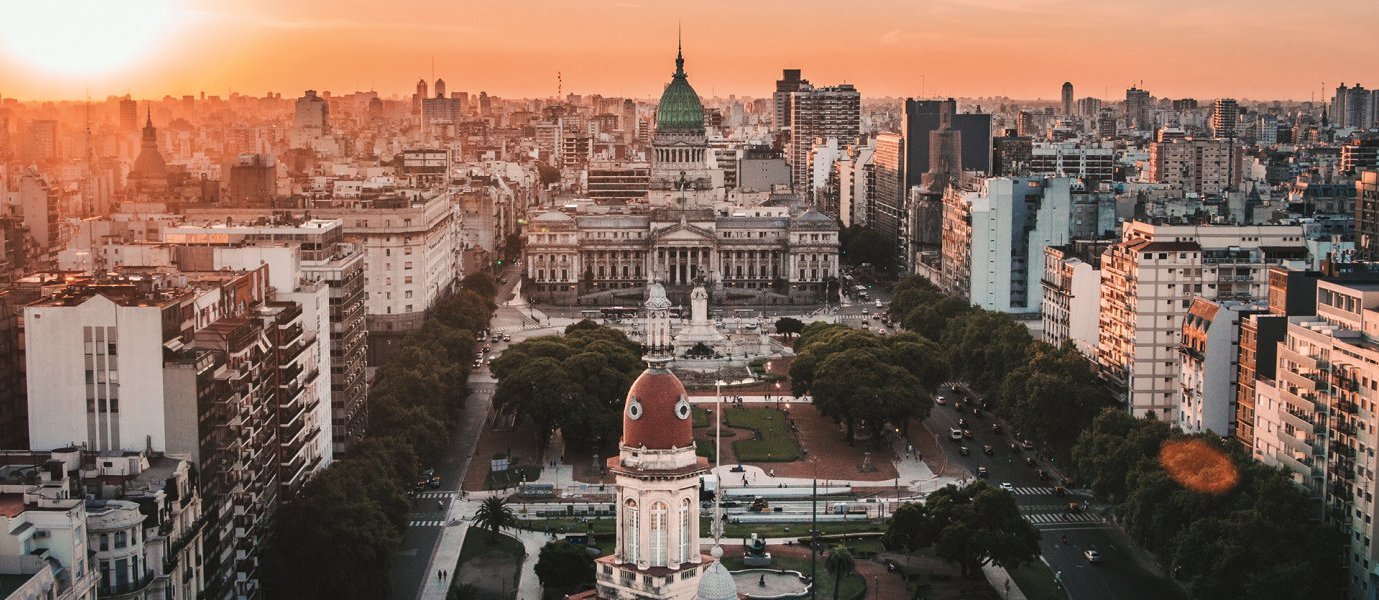
Buenos Aires, home of the famous tango and the capital city of Argentina. Home to 13 million Argentines, Buenos Aires is named one of South America's most electrifying cities. With its temperate climate it's an ideal location for exploring the outdoors and many of Buenos Aires parks and open spaces any time of the year. Buenos Aires also has a very efficient and large public transport network with buses, metros, and a system that makes it easy for cyclists to get through and around the city in a bike friendly way. This photo shows the city center of Buenos Aires and a popular attraction of the city. Photo by Tim Snell.
3 Landmarks
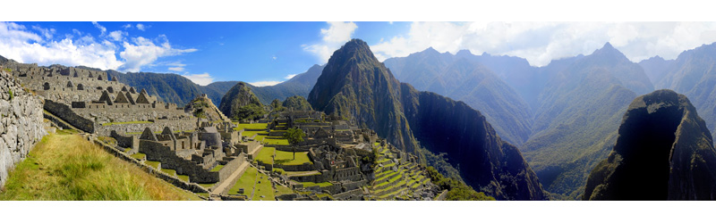 Machu Picchu located high in the Andes Mountains of Peru is an Incan citadel built in the 15th-century. It is the most famous archaeological site on all of South America, surrounded by lush vegetation and the steep, vast mountains. According to my South America travel book, Machu Picchu was never revealed to the conquering Spaniards and was forgotten about until the early part of the 20th century. The site is now limited to 5,940 visitors per day making planning your trip to this sacred land slightly more difficult than before. You can easily see the green, lush vegetation surrounding the site of Machu Picchu and the surrounding heights of the mountains. Photo by Mark Green- Shutterstock.
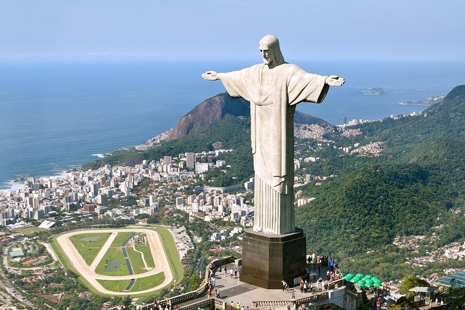
Overlooking Rio de Janeiro stands Cristo Redentor known as Christ the Redeemer in English, designed by engineer Heitor da Silva Costa and sculpted by Paul Landowski is covered in 6 million stone tiles. The original design was supposed to be Christ holding a cross in one hand and a globe in the other and became to the design it is today with Christ's arms wide open. Standing 98 feet tall the statue took 9 years to complete and is often having to be repaired due to weather, with the original stone tiles so hard to find the updates will look a little different than before. The photo above shows visitors surrounding the statue, due to elevators and escalators being installed in 2003 it is much easier for tourists to reach the top. Photo by Getty Images.
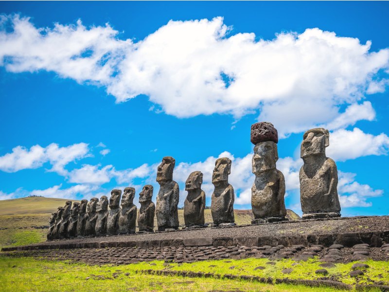
Rapa Nui also known as the famous Easter Island is located in the southeastern region of the Pacific Ocean. Easter Island a Polynesian island, being a territory of Chile although being 2,300 miles off the west coast of Chile, is one of the most mysterious places in the world. Easter Island is only 117 square miles, making it difficult to be located it's a mystery how settlers came upon the island on Easter Day back in 1722. The large figurines shown in the picture above are scattered all throughout the island. These statues stand as tall as 13 feet and can weigh up to 14 tons. Unknown photo source.
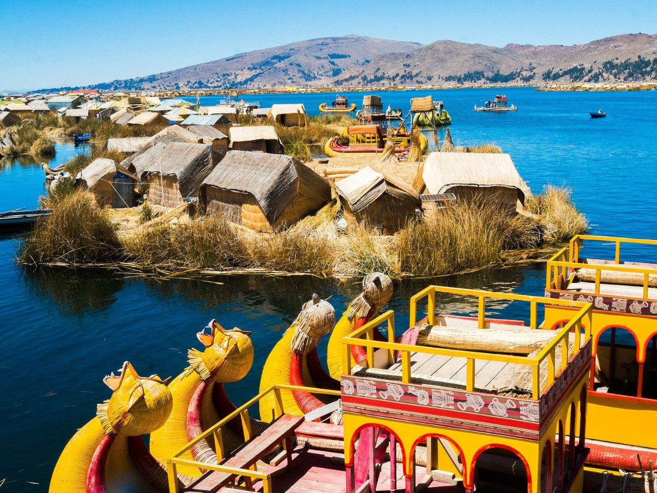
The largest freshwater lake in South America and located within the Andes Mountains between Bolivia and Peru sits Lake Titicaca. Lake Titicaca is the world's highest lake lying at 12,500 feet above sea level with the average depth levels between 460 and 600 feet. More than 25 rivers empty into Lake Titicaca and like any other river, the levels fluctuate during seasons. Due to the size of the lake, it creates a more humid climate for the surrounding area making quinoa and potato cultivation possible at the elevation. The Indigenous people living on Lake Titicaca live on floating islands made entirely of reeds that grow along the shore of the water shown in the photo. Photo- Shuttershock.
4 Images of People
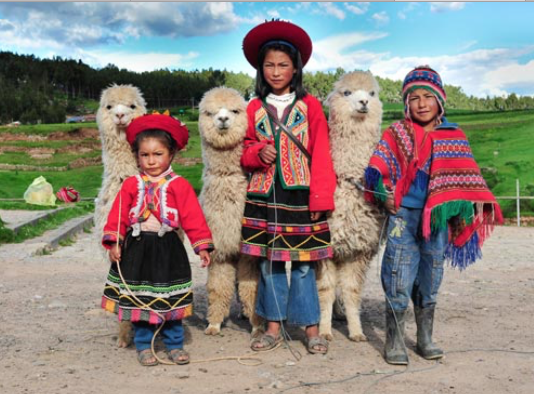
Not only is Peru known for the Incan ruins up high in the Andes mountains, but also Peru is known for their llamas and alpacas. Llamas and alpacas are native to Peru, where about 90% of the alpacas in the world reside in Peru and 26% of the llamas. There are about two dozen llamas that still call Machu Picchu home. Here in the photo stands three children with what looks to be three alpacas, in the traditional bright colored dress that is so familiar to the Peruvian culture. Photo by Jacek Kadaj- Dreamstime.com
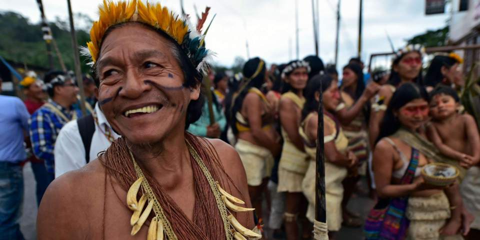
The Amazon Basin is home to many indigenous tribes within the eight countries the Amazon is associated with. It is believed there is around 20 million people living within these territories. These indigenous tribes still continue traditions and practices that have been around for thousands of years. Hunting, fishing, and gathering and most important for learning how to survive in the rainforest as well as farming by the method of shifting cultivation. These indigenous tribes are in danger due to the exploitation and deforestation of the Amazon. This photo was taken after several indigenous people from Amazon tribes went to court to save the Amazon from oil company greed. Photo found on intelligentliving.co

Majority of Chile's population is made up of the European ethnic group, actually 59% of the countries population. Mestizos make up the second largest ethnic group in Chile, they make up 25% of the Chilean population. The word Mestizo refers to people of mixed ethnicity or race living in Latin America. This photo shows a group of Chileans cheering on their national football (soccer) team and showing their spirit with their countries flag painted on their faces, as well as sporting their nation's colors. Chileans are very proud people. Photo found on worldatlas.com
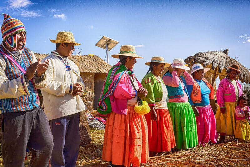
The Uru or Uros people are an indigenous group of humans that reside in Peru and Bolivia on the floating islands of Lake Titicaca. The Uros people have been living on the lake for hundreds of years, they were forced to live on the floating islands when the Incas took over their land. You see in the background of the photo the houses and the umbrella that they've built out of the reed that lines the sides of the lake. The Uros people can be seen in the photo in their bright, traditional colors and hats to block the sun. It almost looks as if they're getting ready for a ceremony or celebration. Photo found on howtoperu.com
5 Images from the Book
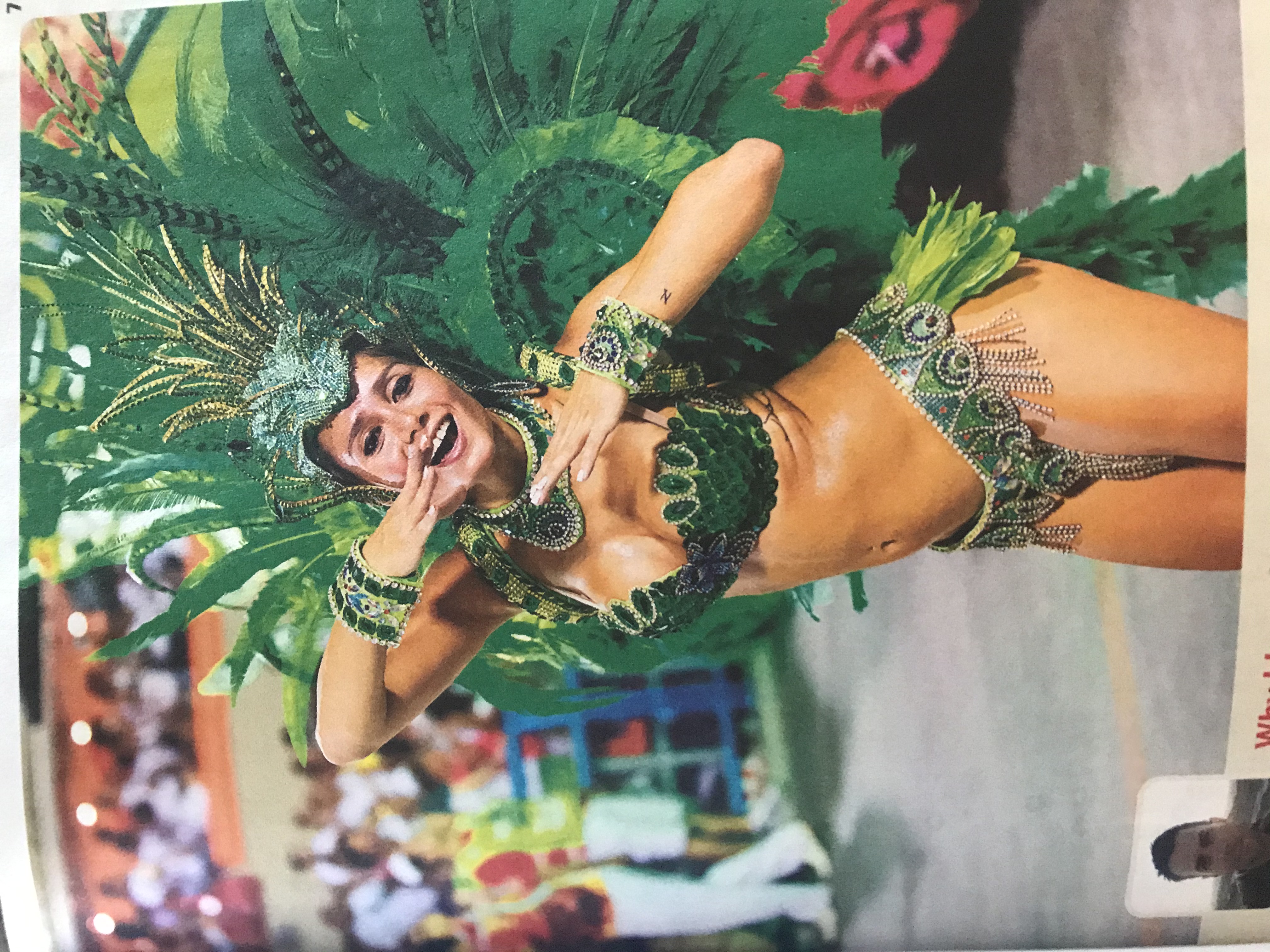
Carnaval is celebrated all throughout the western world, in the Caribbean and countries in South America, the celebrations can continue for weeks at a time. I was lucky enough to experience Carnaval celebrations first hand on the island of St. Thomas, with music, dancing and lots of drinking. It was a lot of fun interacting with the locals of St. Thomas and seeing how welcoming and fun they were. This photo shows a woman participating in the Carnaval celebrations in Rio de Janeiro with her head dress and exciting jeweled outfit. Photo from my South America Lonely Planet book.
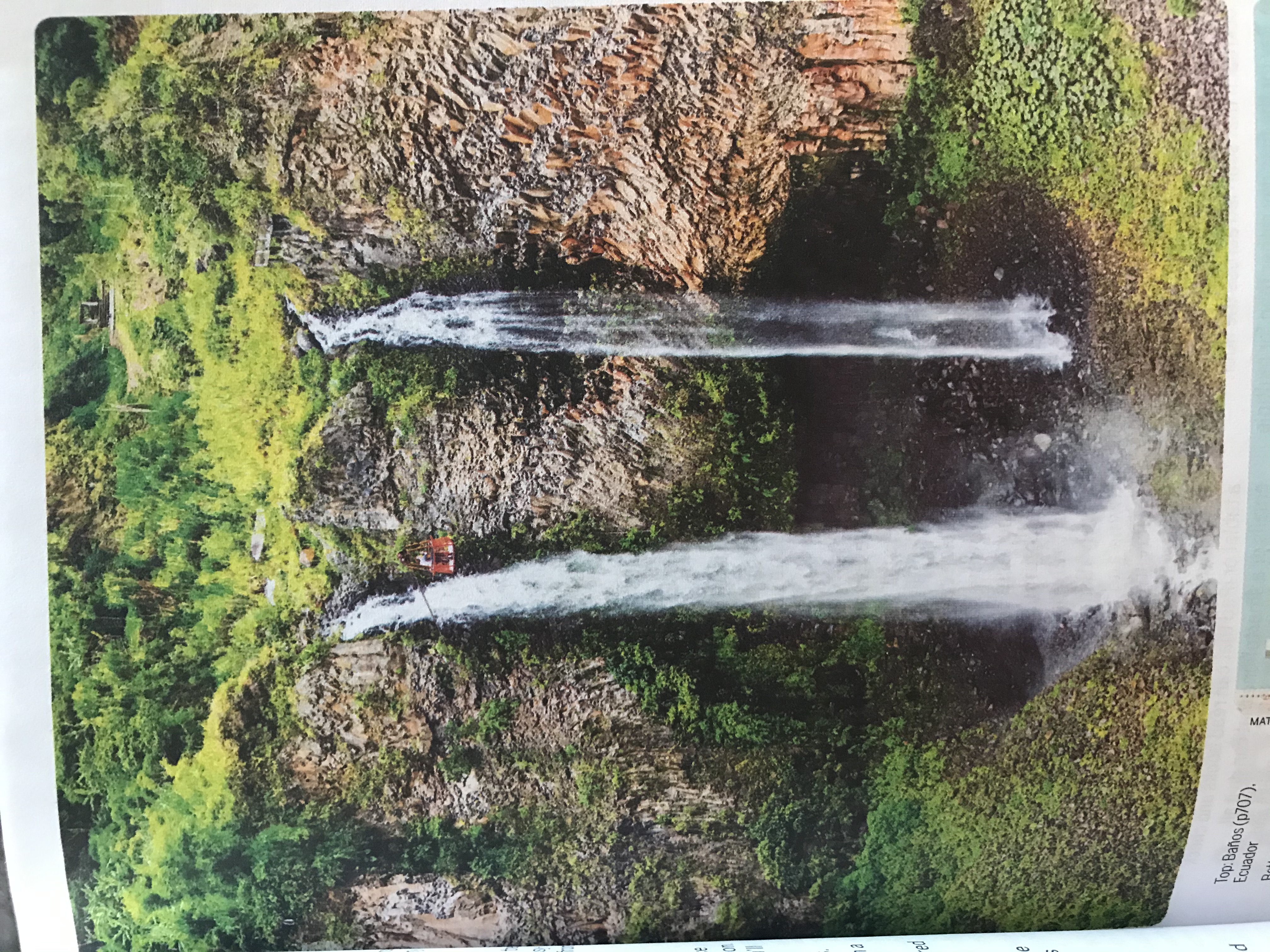
This photo shows the beauty of Banos a city in Ecuador, full name Banos de Agua Santa. This city is a gateway to the nearby Amazon Basin with the active volcano Tungurahua close by and plenty of trails to hike on. This photo is displaying the beautiful waterfalls that can be found all throughout Banos with the lush, green forest surrounding it. Banos is also known for their thermal springs and amazing hiking trails. Being more of an adventurous and outdoorsy type, Banos is definitely a location I'd love to visit and will be making it on my itinerary. Photo from my South America Lonely Planet book.
Submitted by Hannah Lambert on April 12, 2020.